
The Beginner’s Guide to APRS Radios: Off-Grid Tracking & Comms Without Cell Service
Want your radio to do more than voice calls? Discover how to automatically report location, send short messages, log tracks, and push telemetry to online maps completely free of charge.
What is APRS? (And Why It Beats Satellite Intercoms)
APRS (Automatic Packet Reporting System) was developed by visionary amateur radio operators to send tactical data packets over airwaves. Think of it as a decentralized, low-bandwidth, open-source internet that rides on top of pure radio frequencies.
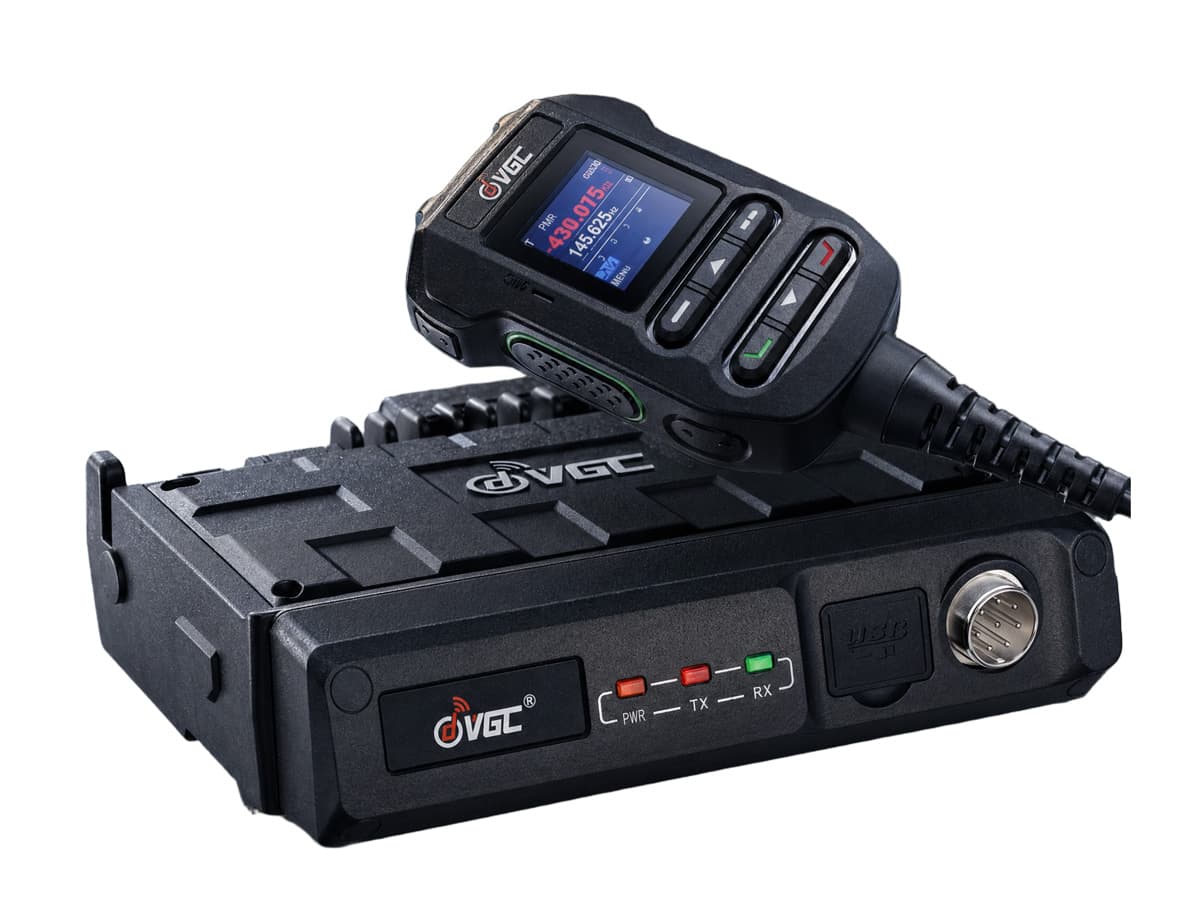
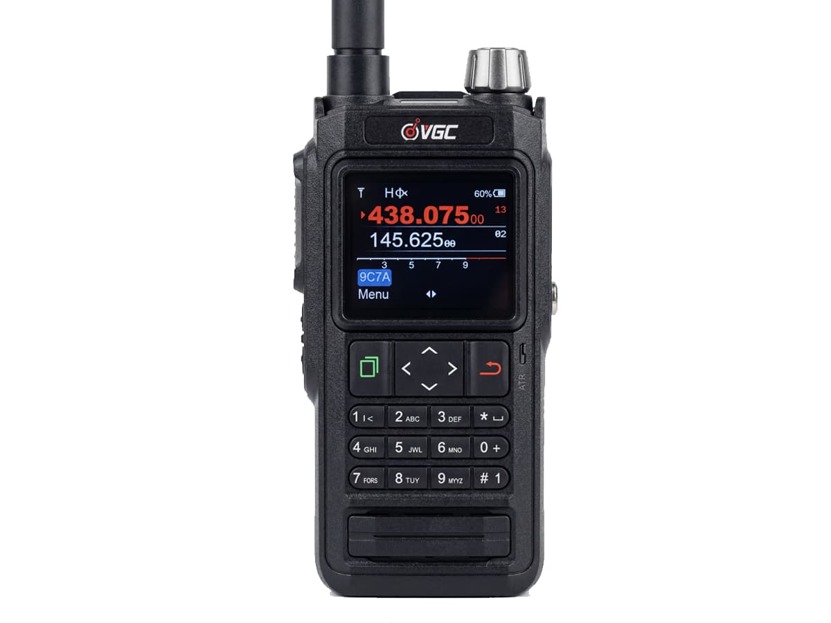
Whether you choose a compact handheld APRS radio or a heavy-duty dashboard-mounted APRS GPS radio, the concept is simple: your device grabs your GPS coordinates, translates them into a stream of audio tones (AX.25 protocol), and blasts it out over the air.
If another station is nearby over RF, they see you instantly. If your packet hits an IGate (Internet Gateway), it gets forwarded to the global APRS-IS database, allowing loved ones back home to track your live overland rig or hiking trail on map engines like APRS.fi—with absolute zero monthly subscription fees or cellular coverage required.
📍 Knowledge Drop: Where to Tune Your APRS Radio
APRS heavily relies on standardized simplex frequencies. Before heading out, dial your secondary VFO channel into the localized packet frequency:
- North America (U.S. / Canada): 144.390 MHz VHF (The most active grid globally)
- Europe & Russia: 144.800 MHz VHF
- Australia & New Zealand: 145.175 MHz VHF
- China: 144.640 MHz VHF
Core Features: What Can an APRS Radio Actually Do?
An advanced handheld ham radio with APRS and GPS isn't just an emergency tracking beacon—it is an off-grid data 瑞士军刀:
| Feature | What It Does For You |
|---|---|
| Automatic Position Beacons | Broadcasts your live telemetry at tailored smart intervals, populating your position on tactical maps for convoy or search-and-rescue teams. |
| RF Tactical Messaging | Sends point-to-point text messages over pure analog radio waves. It can even bridge text messages out to standard mobile phones (APRS-to-SMS gateways). |
| Track Logging | Records breadcrumb trails for safety debriefs—crucial for deep backcountry trail blazers utilizing an APRS tracker for hiking. |
| Telemetry & Weather Reports | Pushes distributed sensor data (battery voltages, temperatures) or fetches real-time localized weather telemetry away from civil grids. |
| Tactical Objects Drop | Allows you to pin temporary virtual icons on everyone's screens in your group (e.g., medical tents, raw obstacles, water crossings). |
The Pro-User Masterclass: Understanding Digipeater Paths (WIDE1-1, WIDE2-1)
The biggest mistake APRS beginners make is incorrectly configuring their Digipeater Path. If you set it wrong, your radio will clog local frequencies, and local network operators (Sysops) might filter your packets out. Here is how the pathing logic works under the hood:
• WIDE1-1 (The Home Digipeater): Tells low-altitude fill-in local repeaters near your vehicle to repeat your packet once.
• WIDE2-1 (The Wide Mountain Mountain-top): Tells high-altitude wide-area repeaters on mountain tops to bounce your packet a second time.
The Ultimate Rule of Thumb: For standard vehicle operations or when carrying a handheld APRS radio in a valley, set your path configuration precisely to WIDE1-1, WIDE2-1. Never configure paths like WIDE2-2, WIDE3-3 unless you are running a high-altitude scientific balloon project—otherwise, you are just flooding airwaves with unnecessary RF echo.
How to Choose a Good APRS Radio: Look For the Ecosystem
When exploring the market for the best APRS transceiver, avoid old legacy setups that trap you in the 1990s hardware constraints. Ensure your buying decision checklist includes:
- Built-in high-sensitivity GPS: External GPS dongles tangle up in your cockpit or gear loops. Go for an all-in-one chassis that achieves fast orbital locks.
- High-Capacity Battery Lifecycle: Sending automated packet data bursts regularly consumes serious power. Look for a minimum of a 2500 mAh battery pack or an easy external 12V direct dashboard hardwire option.
- Software-Defined App Integration: This is the major boundary line in 2026. Traditional APRS radios force you to view positioning maps on a 2-inch low-res pixel screen. The smartest upgrade choice is a radio that embeds a Bluetooth KISS TNC platform. This lets the radio act as the high-power transceiver engine while wirelessly throwing full-color topo maps, tracking radar, and keyboard text entry straight onto your larger smartphone or vehicle Android head unit console.
The Ultimate VERO / VGC APRS Ecosystem
At VERO Global Communication (VGC), we design equipment specifically for modern off-grid expeditions. We bypassed traditional clunky menus and engineered full smartphone-to-dashboard app-defined radio architecture.
Frequently Asked Questions (FAQ)
Q: Will APRS reveal my exact real-time location to the public?
Yes. APRS packets are unencrypted RF signals broadcast openly over airwaves. Anyone with an APRS radio or monitoring websites like APRS.fi can see your telemetry. If privacy is an absolute priority in specific tactical zones, use generalized callsigns or turn off automated beacon intervals temporarily.
Q: Does APRS packet telemetry clog voice repeaters or channels?
No. APRS broadcasts packets on dedicated digital simplex data frequencies (like 144.390 MHz in the USA). It will never affect your standard voice repeater chats. However, keep your packet intervals balanced (every 3 to 5 minutes while moving) to avoid overloading the localized digital packet channel.
Q: How does an APRS radio setup compare to commercial satellite trackers?
Commercial devices (like Garmin inReach or SPOT) route through private satellite constellations and force you into expensive monthly service subscriptions. APRS is completely community-driven, utilizing localized repeater grids and ground IGates entirely free of recurring service charges.